понедельник, 26 октября 2020 г.

DJI Launches P1 and L1 - Photogrammetry and Lidar Payloads for the M300 RTK


DJI Launches Two New Payloads for the M300 RTK

p1&L1-裁图1@2x

DJI has launched two new payload solutions for its flagship commercial drone platform Matrice 300 RTK, designed to serve the most demanding aerial surveying missions. The P1 and L1 are set to change the game, bringing more efficiency and enhanced data accuracy to a variety of surveying scenarios, meeting stringent industrial requirements at an affordable cost.

Learn More about the P1
Learn More about the L1

пятница, 17 июля 2020 г.

QGIS and Free Mobile Applications

Perhaps an example of the growing power of QGIS is how mobile applications have been integrated with this tool in recent years. Mobile applications are becoming popular in their use for data collection, particular in the field when researchers or data collectors are deployed to capture relevant geospatial data. These tools can now be integrated and work with QGIS as a way to interface with QGIS while you are on their mobile device. 
Two popular tools that do this are QField, developed by OPENGIS.ch, and Input, developed by Lutra Consulting. These tools are very similar and both work off project files in QGIS so that they can work with and synchronize with a QGIS project. Both the tools are available on Android devices, while Input is also available in iOS.


пятница, 10 июля 2020 г.

Is Utility GIS Ready for Augmented Reality?

Augmented reality is a great technology, but only works with accurate information.


Замечательная статья о том что самые современные технологии дополненной реальности малоэффективны без контрольной/исполнительной топосъёмки в открытой траншее

вторник, 28 апреля 2020 г.

Что такое "высота" на самом деле?

Отличная и, что главное, не очень большая по размеру статья про то что мы имеем ввиду когда говорим "высота".
Разбита на четыре основных части. Полезна к вдумчивому чтению для понимания что же измеряется на самом деле разными геодезическими приборами.


П.С. Лично мне забавно некое совпадение что в СССР темой геоида занимался Молоденский, а в США Zilkoski.

четверг, 16 апреля 2020 г.

Klau Geomatics launches MakeItAccurate GNSS correction service

Klau Geomatics has launched MakeItAccurate, a global GNSS data correction and processing service.
MakeItAccurate takes data from any GNSS receiver on drone or survey equipment and makes it accurate. Users can now achieve centimeter (cm)-level accuracy without the need for base stations, real-time kinematic (RTK) links, data from Continuously Operating Reference Station (CORS) or other external inputs.
MakeItAccurate requires only the raw GNSS data from a drone to produce a highly precise trajectory and turn the traditional autonomous 3-5m GPS accuracy to 3-5 cm anywhere in the world.

четверг, 5 марта 2020 г.

Carlson Scan2K creates accurate 3D point clouds with a range up to 2000 meters

The Carlson Scan2K is Carlson’s latest lidar solution for the creation of accurate 3D point clouds with ranges up to 2,000 meters under the right conditions. The Scan2K was designed with a total station workflow in mind simplifying the field data collection and georeferencing procedures. The Scan2K was designed with the surveying and mining environment in mind and is at home in the field with its weather-proof IP64 housing, sunlight-visible touch screen interface with intuitive menu-driven operations for quickly collecting and georeferencing point cloud data. The Scan2K features an integrated high-resolution camera, inclinometers, a compass, and an L1 GNSS receiver. The Scan2K can be deployed in various environments and orientations, including mobile and kinematic operations.

Read more...

пятница, 7 февраля 2020 г.

Cохранение окна карты с WMS в виде файла TIFF с геопривязкой и указанным разрешением в qGIS

Иногда очень хочется сохранить WMS того-же ортофото в виде файла с геопривязкой на всякий случай.
С qGIS сделать это довольно легко
  • Создаем или открываем проект, устанавливаем СК MR99.  Добавляем например ортофото
  • Масштабируем окно карты чтобы оно охватывало полностью интересующую вас зону. Правый клик на слое WMS, далее Save As

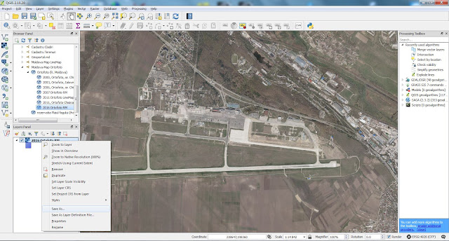
  • Появляется окно Save raster layer as
Устанавливаем следующие опции
  • Убираем галочку Create VRT
  • Save as - указываем путь и даем название файлу
  • CRS - EPSG4026
  • Extent - нажимаем  Map view extent, иначе будет создаваться растр на весь охват слоя WMS
  • Resolution - это размер пикселя в единицах карты - метрах. Если вы планируете использовать растр как подложку для печати например масштаба 1:2000, тогда 0.5м пиксель вполне достаточен. У ортофото 2016 размер пикселя 0.2м
  • Create Options - High compression. Далее нажимаем "+" и пишем в колонке Name - tfw, а в колонке Value - yes
Если будет ругаться "Cannot validate creation options" - не расстраивайтесь, жмите Close
Должно появиться окошко сохранения растра - чем больший охват захотелось и чем меньше разрешение, тем дольше будет сохранение. Терпение - величайшее из добродетелей.

Поглядим что получилось - файл размером 88МБ

Вот с такими пикселями