Показаны сообщения с ярлыком gis. Показать все сообщения

понедельник, 13 ноября 2023 г.

Greater London brings all data providers onto National Underground Asset Register

 Greater London has become the first part of the country in which all major utilities providers and local authorities are providing data for the National Underground Asset Register (NUAR).


The Greater London Authority (GLA), which is part of the NUAR delivery team, said it has brought over 60 asset owners in the city onto using the register, providing records of over 16 million assets.

The early version of register was formally launched by the Geospatial Commission in April. It is a digital map providing details of underground cables and pipes, being rolled out around the UK to support the installation of further infrastructure.

Read more...

воскресенье, 16 июля 2023 г.

Water and sewer GIS map creation for the mun. Straseni, Republic of Moldova

In the year 2021 I was involved into creation of water and sewer GIS map for the mun. Strășeni. 

QGIS software and shape file were adopted as a standard for the map. Line map 2017 and orthophoto 2020 was set as a base map for the water and sewery map. National coordinate system MOLDREF99 and Baltic 1977 was set up for the project.

At that moment only map data were on paper - cadaster map printed at scale approximatively 1:4000 with hand drawn water lines. This situation happened because of  rehabilitation of water system in mun. Strășeni in 2000s was done without creation of as built documentation. 


A lot of sewery lines built before 1990s were digitized from city topo plans 1:500

Sewery lines built after 2015 has been documented with as built survey 1:500 in AutoCAD drawing

After all existing paper documents (including topo plans 1:500) and AutoCAD drawings were processed and "paper" data "moved" to a digital map, we started next step. Map was divided into pages printed at scale 1:1000 and water company personnel checked it and completed.

 Overview of atlas pages.
    After all corrections and completions were done the final map was printed again and organized into atlas.

    QGIS projects windows looks like:


понедельник, 5 декабря 2022 г.

Polk County residents and officials disagree on property lines

As residents accuse the county of moving property line markers while surveying land for its online GIS database, Polk County officials say residents who have misunderstood property descriptions for years are to blame.

пятница, 10 июля 2020 г.

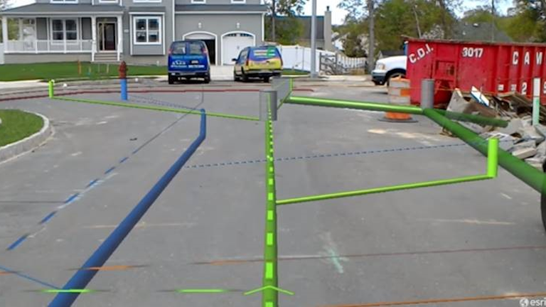
Is Utility GIS Ready for Augmented Reality?

Augmented reality is a great technology, but only works with accurate information.


Замечательная статья о том что самые современные технологии дополненной реальности малоэффективны без контрольной/исполнительной топосъёмки в открытой траншее

пятница, 26 апреля 2019 г.

A new version of Sputnik GIS presents new tools, optimized performance, usability, and new integration capabilities - GISuser.com

A new version of Sputnik GIS presents new tools, optimized performance, usability, and new integration capabilities - GISuser.com: RECRUITERS Post your GeoJob Ad Today Sputnik GIS is a professional drone surveying software for engineers, surveyors, and urban planners. Visualize and analyze multidimensional spatial data with no limits on data size, create surveys and get insights from your drone data in height performance GIS solution. Optimization and integration capabilities: Sputnik GIS 1.4 has a …

воскресенье, 14 октября 2018 г.

Google's BigQuery Brings GIS Into The Petascale Era


Perhaps the greatest challenge confronting today’s “big data” era lies not the acquisition of data, but rather how companies can uncover insights from the chaos of petabytes. Today’s companies have assembled breathtakingly large archives of incredibly rich data but struggle to perform more than basic analyses at scale. This is especially true when it comes to reasoning in terms of the more complex dimensions like time and space. As the world’s data is increasingly geospatially enriched and as companies increasingly need to understand their data in terms of its physical location, we need tools that can query, analyze and reason about immense geospatial data at population scale. Enter Google’s new BigQuery GIS.
Read more...

суббота, 14 июля 2018 г.

BIM vs GIS or BIM and GIS – Why are we still in doubt?

BIM (Building Information Modeling) and GIS (Geographic Information System) are two critical technologies, whose integration can bring exemplary results into digitalconstruction. However, there remains a point of contention in this integration. While a group is stuck with the thought of BIM vs GIS, things are looking up with many experts following a more progressive thought of integrating the two.